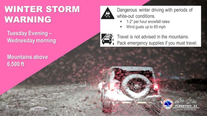
The National Weather Service has issued a Winter Storm Warning for Northern Arizona, including the Williams area. Travel is not advised beginning at 5 PM Tuesday through 5 AM Wednesday, especially above 6500 feet. Lower elevations could be affected too, with snow levels as low as 4000 feet.
The Winter Storm Warning:
URGENT - WINTER WEATHER MESSAGE
National Weather Service Flagstaff AZ
301 PM MST Mon Dec 13 2021
...WINTER STORM WARNING IN EFFECT FROM 5 PM TUESDAY TO 5 AM MST
WEDNESDAY ABOVE 6500 FEET...
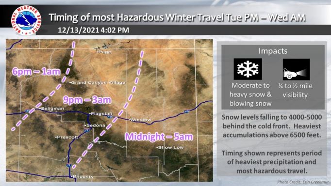
* WHAT...Snow expected above 6500 feet. Total snow accumulations
of 2 to 6 inches, with locally higher amounts possible. Periods
of intense snowfall are likely with rates of 1 to 2 inches per
hour possible between 10 PM Tuesday - 3 AM MST Wednesday.
Southerly wind gusts as high as 65 mph expected with blowing
snow.
* WHERE...Areas above 6500 feet near Doney Park, Flagstaff,
Forest Lakes, Heber-Overgaard and Williams.
* WHEN...From 5 PM Tuesday to 5 AM MST Wednesday.
* IMPACTS...Plan on slippery road conditions. Blowing snow and
intense snowfall rates will significantly reduce visibility
resulting in whiteout conditions and very hazardous travel. Very
strong winds could cause extensive tree damage and power
outages.
* ADDITIONAL DETAILS...The Winter Weather Advisory has been
upgraded to a Winter Storm Warning.
Snow forecast from 5 PM Tuesday to 5 AM Wednesday:
Doney Park 2 to 4 inches Flagstaff 4 to 6 inches
Forest Lakes 3 to 5 inches Heber-Overgaard 1 to 2 inches
Williams 3 to 5 inches.
PRECAUTIONARY/PREPAREDNESS ACTIONS...
If you must travel, keep an extra flashlight, food, and water in
your vehicle in case of an emergency.
The latest road conditions for the state you are calling from can
be obtained by calling 5 1 1.